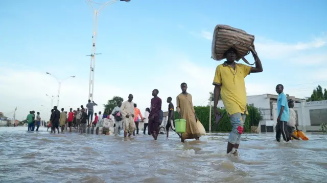
SINCE floods started wreaking havoc in northern states in August, no fewer than 141 lives have been lost in Kano, Niger, Borno, Yobe and Adamawa states.
Kano State topped the chart with 49 deaths, followed by Yobe, 43; Borno, 26; Adamawa,12; and Niger 11.
In Niger State, the Director- General, the State Emergency Management Agency, Abdullahi Baba Aarah, said 11 persons were swept away by flood, adding that 539 communities, 246 schools; 118,692 hectares of farmlands were submerged, following torrential rainfall that caused flooding this year.
Injuries, male colleagues’ attitude almost made me quit welding – Zainab Giwa, Yaba Tech graduate
Besides those killed, 529 communities in 19 of the 25 local governments in the state were affected.
The local governments affected are Mokwa, Katcha Lavun, Lapai, Agaie, Shiroro, Munya, Gbako, Kontagora, Bosso, Edati, Agwara Magama, Bida, Mashegu, Borgu Gurara, Suleja, and Rijau.
On individuals affected, the statistics showed that 41,192 people and 6,865 households, mostly in these local governments, were affected by the flood.
Vanguard reliably gathered that residents of 34 communities have been displaced and are now in Internally Displaced Peoples, IDP, camps in different parts of the state.
With the development, the state and indeed the country may be facing a food crisis as a result of the hectares of farmlands washed away by the flood.
Abdullahi Baba Aarah who confirmed the sad occurrence said the state government has taken more decisive steps to guide against further occurrence.
“We are still expecting more rains and therefore, flooding may still be with us and this is why we are not letting down our guards.
“Sadly, we have lost 11 people to the flood, five in Mokwa local government area, two each in Shiroro and Munya and one each in Katcha and Rijau local government areas.
“In addition, 246 school infrastructure have been washed away, creating accommodation problems for pupils and students and their teachers.
“We can also report that as of September, this year, 18 bridges and 80 culverts have been destroyed by floods, causing communication problems for people in the affected areas.
“With this development, the state may also be facing serious food shortages because the flood has affected 118,692 hectares of farmlands, some of which had crops ready for harvests while over I,600 fish ponds were also washed away.”
Meanwhile, the state government has approved immediate procurement of food and other items while the state Emergency Agency has reached out to stakeholders, donor institutions and international partners for interventions to assist the affected persons.
The NiMET had a few months ago placed Niger State among the first line states of the Federation that would be affected by flood.disaster in Borno and Yobe.
In Borno State, the Director- General of SEMA, Mohammed Barkindo, said it was very difficult to ascertain the actual number of casualties as the government, in collaboration with other stakeholders, was still taking stock.
However, he said: “Currently, 26 persons died, out of which 16 are male, six are female and four are unidentified due to the high level of their decomposed bodies.
“Also about 2.4 million people were displaced and currently taking refuge in camps, while others are living with their relatives and friends in safer areas.”
In Yobe State, the Executive Secretary of SEMA, Dr. Mohammed Goje, said flood hit 17 LGAs with severity in Gashua, Jakusko, Geidam, Jumbam, Girgir, Dapchi, Mutai, Katarko and Bara in Gulani since August this year.
“In Yobe State, we recorded 43 deaths, 486 injured, with 540 communities across 17 LGAs, 26,574 households and 63,795 individuals affected. A total of 39,639 facilities, houses and farmlands were destroyed.”
How 12 died in Adamawa
In Adamawa, no fewer than 12 persons were reportedly killed since the upsurge of flooding commenced in August.
Most of the casualty figures are from the bank of the River Benue and elsewhere in the Northern Adamawa senatorial zone that has not witnessed serious flooding before.
The local government areas worst hit in the zone are Michika, Madagali, Mubi North and Mubi South
Experts attributed the upsurge of flooding in the areas to climate change.
Adamawa Sate Emergency Management Agency said water from Lagdo Dam has started flowing downwards since last weekend, but noted that the magnitude of the flooding was still under control.
Death toll hits 49 in Kano
In Kano, the death toll arising from flooding has risen to 49 from 31, the Executive Secretary, Kano State Emergency Management Agency, Isyaku Kubarachi, disclosed yesterday.
He also said the flood has now affected 27 LGAs of the state, listing the affected areas to include Tudun Wada, Gwale, Wudil, Danbatta, Ajingi, Dala, Gwarzo, Madobi, Bichi, Kano Municipal, Karaye, Tarauni, Minjibir, Bebeji, Rogo, Shanono, Kabo, Garin Malam and Ungogo.
He said others include Kumbotso, Nasarawa, Kura, Dawakin Kudu, Dawakin Tofa, Gezawa, Rogo and Bagwai Local Government areas.
He noted that the flood also affected 226 communities and destroyed 6,583 houses while 38, 814 persons were affected.


